
By Hans Oerlemans & Tobias Volbert; Urban Design Alliance Queensland; 2014; Brisbane; ISBN 979-0-9924423-1-6
By Hans Oerlemans & Nick Stevens (USSC)
Presented at the PIA National Conference 2013 in Canberra, Australia
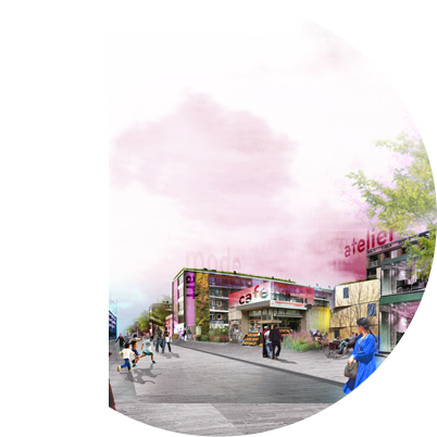
Master plan, schematic design public space and guide lines for further plan development for the transformation of a historical industrial area into a new vibrant multifunctional city district.
Data
| Client: | City of Hengelo, project office Hart van Zuid |
| Location: | Hengelo, The Netherlands |
| Area: | 56 ha. |
| Year: | 1999-2004 |
| Status: | Ratified, under construction |
| Partners: | Dolte town planning, OKRA landscape architects |
More information? Click:
wOnder_Heart of South_Doc_150dpi
or the pdf-icon at the bottom of this page.
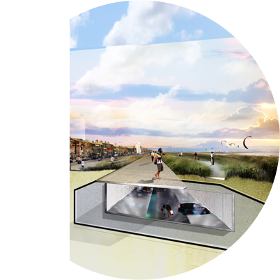
The issue
The city of Meppel is extending into a sensitive cultural landscape. A district half the size of the current city will be developed in the next 25 years. The plan needs to be respectful to the landscape, well connected with the city and produce a finished result in every phase.
Our statement
In New-Peat Lands everybody will live at a meadow, creating a district where city and landscape slide into each other.
Our solution
The typical cultivation pattern of the landscape is the base for the urban plan. Instead of the usual complete filling, we introduce an alternative civil engineering method. Thus we can retain all ditches, as base for both the urban water system and the development framework. Build-up parcels are alternated with agricultural meadow zones. Three distinct ribbons further elaborate the framework. Large-scale recreational facilities and a finely meshed network of paths join the city to the new district and the landscape.
Data
| Client: | City of Meppel |
| Location: | Meppel, The Netherlands |
| Area: | 737 ha. |
| Year: | 2003-2005 |
| Status: | Ratified |
| Partners: | OKRA landscape architects, Tauw environmental consultants, Goudappel Coffeng traffic engineers |
More information? Click:
Nieuwveense Landen_Project Documentation
Nieuwveense Landen_Process & Scenario Game
Nieuwveense Landen_Master Plan Summary
or the pdf-icon at the bottom of this page.
The issue
The National Government aspires to put this area on the UNESCO World Heritage list. Therefore the archaeological values in the landscape need to be protected. Economical detriments need to be compensated within the landscape itself.
Our statement
The two historical layers, now blurred into each other, need to become separately readable. This opens up a whole new world of economical potentials.
Our solution
First we research the possibilities to protect the archaeology. Interactive with all stakeholders, we attune the archaeological ambitions to the acceptable level of new developments. With the outcome, we design a landscape framework, clarifying the rational land-claim. This hosts a set of story lines, illuminating the archaeology. Together they create a clear structure for adding wind turbines, increase recreational attraction and additional income, and thus free up space for the desired archaeological protection.
Data
| Client: | Province of Flevoland, with Lelystad City, Dronten Council, Farmers Coop. Swifterbant |
| Location: | Flevoland, The Netherlands |
| Area: | 38.2 km2 |
| Year: | 2003-2004 |
| Status: | Ratified |
| Partners: | OKRA landscape architects |
More information? Click:
Swifterbant_Project Documentation Swifterbant_Process & Scenario Game
or the pdf-icon at the bottom of this page.
The issue
The National Government has defined the core qualities for the national landscapes. They are striking, but not practical. They need to be made useful for daily practice in planning and design.
Our statement
The essence of making the core qualities practical is to analyse sharply what you see, force to grab it in one image, and explain why it looks that way.
Our solution
By forcing ourselves to grab the landscape in one image only, we get to the essence of its appearance. The image is explained in 5 icons and nuanced with sub- areas. Four characteristic story-lines explain the landscapes appearance and values. The ambitions for improving the key qualities are determined. And we create design principles to assist new developments so they can strengthen the core qualities. This all is done in close cooperation with the people of the Province. The result becomes really their guide.
Data
| Client: | Province of Utrecht |
| Location: | Utrecht, The Netherlands |
| Area: | 1449 km2 |
| Year: | 2009-2010 |
| Status: | Ratified and published |
| Partners: | OKRA landscape architects |
More information? Click:
Quality Guides_Project Documentation
Quality Guides_Project Booklet
or the pdf-icon at the bottom of this page.
Recreation-economical scenario for the development of the 80 km historic important New Dutch Waterline (nominee UNESCO world heritage list).
Data
| Client: | National Government – Project office NHW |
| Location: | The Netherlands |
| Area: | 273 km2 |
| Year: | 2001 |
| Status: | Ratified and published |
| Partners: | OKRA landscape architects |
More information? Click:
New Dutch Waterline_Project Documentation
or the pdf-icon at the bottom of this page.
The issue
The area around 4 historical fortifications is vastly fragmented by infrastructure, both spatial and in their use. Their value for the city is far below their potential. However, there is no budget for large-scale interventions. The transformation needs to be gradual.
Our statement
To create cohesion and increase use and value, the area needs to be strategically opened up. A network of clever vistas and simple pathways will increase value dramatically.
Our solution
The fortifications are part of the New Dutch Water-defence-line, nominated as UNESCO World Heritage. We use the historical profile of this system to create coherence. The fragments are brought together in four zones with complementing atmospheres and functions. Attacking missing links in the connections creates a vast path-system. Strategic vistas highlight the fortifications to the millions of passers-by, who enter the city here by car or train. The area is turned into a modern city-gate and valuable parkland at the same time.
Data
| Client: | City of Utrecht |
| Location: | Utrecht, The Netherlands |
| Area: | 158 ha. |
| Year: | 2006-2008 |
| Status: | Ratified |
| Partners: | OKRA landscape architects |
More information? Click:
Lunetten_Project Documentation
or the pdf-icon at the bottom of this page.
The issue
For 300 years the cathedral square has been the trauma of the city. It is depressing and inhospitable, but the community is incapable to deal with changing it. A process of revealing the 2000-year history of the square should change the citizens’ perception. Marking the roman castellum wall is the first physical intervention, a test case for the whole operation.
Our statement
The mysterious referring to hidden pasts of the marking makes people curious, amazed and keep them intrigued, also when they pass it daily.
Our solution
History is a great inspiration. The original wall lies buried 4 meter below the surface. Its ruins were overgrown by woods in the middle ages. We design the marking with the exact measurements of the wall. Rusty corten steel refers to the soil and woods. The engraving shows map fragments of the boarders of the Roman Empire. Once an hour fog and green light rises from the marking, like a wall in mysterious swamp forest. On special days of the year the colour changes, adding to the festivity and keeping people surprised.
Data
| Client: | Domplein 2013 Foundation |
| Location: | Utrecht, The Netherlands |
| Area: | 149 m1 |
| Year: | 2006-2010 |
| Status: | Competition winner, Constructed |
| Budget: | € 1.1 million |
| Partners: | OKRA landscape architects, Rots Maatwerk |
More information? Click:
Dom Square_Project Documentation
or the pdf-icon at the bottom of this page.
The issue
This unique medieval landscape of national cultural importance is gradually consumed by the surrounding cities. The province, three councils and water-board together commissioned a development-plan for the next 20 years.
Our statement
To preserve this extraordinary landscape, a new relation between cities and landscape, between ‘citizens’ and ‘farmers’ is needed.
Our solution
Together with stakeholders and rural communities we have developed a plan that brings cities and landscape in contact again. The cities transform their backsides into green fronts, viewing to the landscape. Recreational networks and rural programs invite the citizens into the landscape, making them allies in the preservation. Each party is made responsible for specific follow-up projects, keeping each other attentive.
Data
| Client: | Province of Overijssel, with Zwolle City, Kampen City, Zwartewaterland Council, Waterboard Groot Salland |
| Location: | Overijssel, The Netherlands |
| Area: | 99.8 km2 |
| Year: | 2001-2003 |
| Status: | Ratified |
| Partners: | Dolte Town Planning, OKRA landscape architects |
More information? Click:
Mastenbroek_Project Documentation
or the pdf-icon at the bottom of this page.